
TremorViz
![]()
![]()
In 2018, I had the privilege of taking part in Geohackweek, a week-long event from the UW eScience Institute that brings together people from academia and industry to learn about and practice the latest developments at the intersection of data science and geospatial analyses.
On the first day, some participants pitched general project ideas and recruited people to flesh out and work on those projects with them. Because I had been thinking a lot about interactive data visualizations, I joined three other participants to work on improving data visualizations of seismic tremor data.
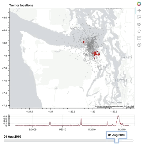
My Bokeh version of TremorViz
In the end, our original vision for a what our interactive visualization would look like was not quite achieved. But in the process, we learned a ton about visualization, particular packages, and their limits. We ended up producing two versions of the visualization, each with some of the original elements we desired. Major credit to our team lead, Ariane Ducellier, for getting a running version of the tool working using the Altair package. Our team GitHub repo, ghw2018_tremorviz, has her code as well as my Bokeh version.